
Fichier:Somerset UK locator map 2010.svg

Taille de cet aperçu PNG pour ce fichier SVG : 494 × 600 pixels. Autres résolutions : 198 × 240 pixels | 395 × 480 pixels | 633 × 768 pixels | 843 × 1 024 pixels | 1 687 × 2 048 pixels | 1 108 × 1 345 pixels.
Fichier d’origine (Fichier SVG, nominalement de 1 108 × 1 345 pixels, taille : 302 Kio)
| Ce fichier et sa description proviennent de Wikimedia Commons. | Accéder au fichier sur Commons |
Larissa
Description
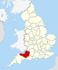
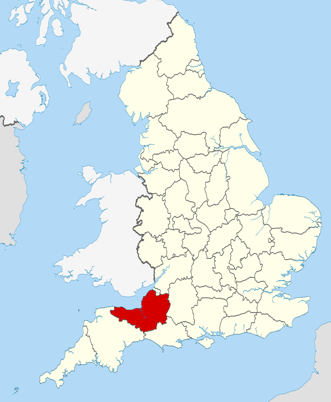
| Description | Location of the ceremonial county of Somerset within England. |
| Date | |
| Source |
National Geospatial-Intelligence Agency
|
| Auteur | Nilfanion |
Conditions d’utilisation
Moi, en tant que détenteur des droits d’auteur sur cette œuvre, je la publie sous les licences suivantes :
Ce fichier est disponible selon les termes de la licence Creative Commons Attribution – Partage dans les Mêmes Conditions 3.0 (non transposée).
- Vous êtes libre :
- de partager – de copier, distribuer et transmettre cette œuvre
- d’adapter – de modifier cette œuvre
- Sous les conditions suivantes :
- paternité – Vous devez donner les informations appropriées concernant l'auteur, fournir un lien vers la licence et indiquer si des modifications ont été faites. Vous pouvez faire cela par tout moyen raisonnable, mais en aucune façon suggérant que l’auteur vous soutient ou approuve l’utilisation que vous en faites.
- partage à l’identique – Si vous modifiez, transformez, ou vous basez sur cette œuvre, vous devez distribuer votre contribution sous la même licence ou une licence compatible avec celle de l’original.

|
Vous avez la permission de copier, distribuer et modifier ce document selon les termes de la GNU Free Documentation License version 1.2 ou toute version ultérieure publiée par la Free Software Foundation, sans sections inaltérables, sans texte de première page de couverture et sans texte de dernière page de couverture. Un exemplaire de la licence est inclus dans la section intitulée GNU Free Documentation License. |
Vous pouvez choisir l’une de ces licences.

|
Ceci est une des images constituant une partie de l'ensemble d'images de valeur : Locator maps of the Ceremonial counties of England, sur Wikimedia Commons. Le groupe d'images a été validé selon les critères pour les ensembles d'images de valeur et a été considéré comme étant l'ensemble possédant la plus grande valeur sur Commons dans la thématique :
Locator maps of the Ceremonial counties of England
Vous pouvez consulter la proposition sur Commons:Valued image candidates/Locator maps of English ceremonial counties. |
Historique du fichier
Cliquer sur une date et heure pour voir le fichier tel qu'il était à ce moment-là.
| Date et heure | Vignette | Dimensions | Utilisateur | Commentaire | |
|---|---|---|---|---|---|
| actuel | 23 novembre 2010 à 22:43 | | 1 108 × 1 345 (302 Kio) | Nilfanion | == Summary == {{Information |Description=Location of the ceremonial county of Somerset within England. |Source=Ordnance Survey [https://www.ordnancesurvey.co.uk/opendatadownload/products.html OpenData]: *County boundar |
Utilisation du fichier
La page suivante utilise ce fichier :
Usage global du fichier
Les autres wikis suivants utilisent ce fichier :
- Utilisation sur af.wikipedia.org
- Utilisation sur an.wikipedia.org
- Utilisation sur ar.wikipedia.org
- Utilisation sur arz.wikipedia.org
- Utilisation sur ast.wikipedia.org
- Utilisation sur az.wikipedia.org
- Utilisation sur be-tarask.wikipedia.org
- Utilisation sur bg.wikipedia.org
- Utilisation sur bn.wikipedia.org
- Utilisation sur br.wikipedia.org
- Utilisation sur ca.wikipedia.org
- Utilisation sur ceb.wikipedia.org
- Utilisation sur cs.wikipedia.org
- Utilisation sur de.wikipedia.org
- Utilisation sur en.wikipedia.org
- Somerset
- Exmoor Horn
- Staple Hill (Somerset)
- Two Moors Way
- Weston-super-Mare (UK Parliament constituency)
- Keynsham Humpy Tumps
- Bathwick
- North East Somerset (UK Parliament constituency)
- Claverton Down
- Template:Somerset-geo-stub
- Quants Reserve
- Lansdown, Bath
- Lulsgate Plateau
- Bristol Reservoirs
- Bowlditch Quarry
- Brockley Hall Stables
- Hartcliff Rocks Quarry
- Ham Green SSSI
- Hinton Charterhouse Field
- Hinton Charterhouse Pit
- Hinton Hill, Wellow
- Holly Lane SSSI
- Huish Colliery Quarry
- Lulsgate Quarry
- Kenn Church, Kenn Pier & Yew Tree Farm SSSI
- Tickenham, Nailsea and Kenn Moors SSSI
- Hobbs Quarry SSSI, Shepton Mallet
- Ben Knowle
- Doulting Railway Cutting
- Viaduct Quarry
- Friar's Oven
- Hurcott Lane Cutting
Voir davantage sur l’utilisation globale de ce fichier.