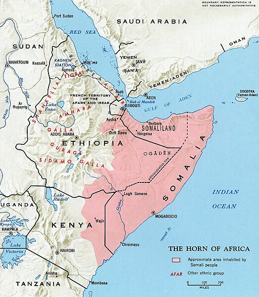
Fichier:Somali map.jpg
Apparence

Taille de cet aperçu : 523 × 599 pixels. Autres résolutions : 209 × 240 pixels | 419 × 480 pixels | 670 × 768 pixels | 1 055 × 1 209 pixels.
Fichier d’origine (1 055 × 1 209 pixels, taille du fichier : 420 Kio, type MIME : image/jpeg)
Historique du fichier
Cliquer sur une date et heure pour voir le fichier tel qu'il était à ce moment-là.
| Date et heure | Vignette | Dimensions | Utilisateur | Commentaire | |
|---|---|---|---|---|---|
| actuel | 19 décembre 2024 à 12:48 |  | 1 055 × 1 209 (420 Kio) | Rabacha | Reverted to version as of 16:12, 26 May 2024 (UTC) this is an old CIA map, seemingly a paper scan. Removed the editorial vandalism. |
| 26 mai 2024 à 20:16 |  | 1 280 × 1 465 (1,92 Mio) | Jacob300 | Reverted to version as of 11:01, 5 February 2024 (UTC) | |
| 26 mai 2024 à 16:12 |  | 1 055 × 1 209 (420 Kio) | SawsanJojo | Reverted to version as of 15:12, 3 February 2024 (UTC) | |
| 5 février 2024 à 11:01 |  | 1 280 × 1 465 (1,92 Mio) | Jacob300 | Reverted to version as of 18:33, 2 February 2024 (UTC) | |
| 3 février 2024 à 15:12 |  | 1 055 × 1 209 (420 Kio) | Janik98 | Reverted to version as of 13:23, 19 January 2024 (UTC) original CIA map, if you want to add Somaliland just upload a new version of this file | |
| 2 février 2024 à 18:33 |  | 1 280 × 1 465 (1,92 Mio) | Jacob300 | Reverted to version as of 19:30, 12 January 2024 (UTC) | |
| 19 janvier 2024 à 13:23 |  | 1 055 × 1 209 (420 Kio) | Janik98 | Reverted to version as of 17:51, 10 January 2024 (UTC) original CIA map, if you want to add Somaliland just upload a new version of this file | |
| 12 janvier 2024 à 19:30 |  | 1 280 × 1 465 (1,92 Mio) | Jacob300 | Reverted to version as of 06:59, 10 January 2024 (UTC) | |
| 10 janvier 2024 à 17:51 |  | 1 055 × 1 209 (420 Kio) | Janik98 | Reverted to version as of 14:32, 6 January 2024 (UTC) original CIA map, if you want to add Somaliland just upload a new version of this file | |
| 10 janvier 2024 à 06:59 |  | 1 280 × 1 465 (1,92 Mio) | Subayerboombastic | Reverted to version as of 21:05, 31 December 2023 (UTC) |
Utilisation du fichier
La page suivante utilise ce fichier :
Usage global du fichier
Les autres wikis suivants utilisent ce fichier :
- Utilisation sur af.wikipedia.org
- Utilisation sur af.wiktionary.org
- Utilisation sur am.wikipedia.org
- Utilisation sur ar.wikipedia.org
- Utilisation sur arz.wikipedia.org
- Utilisation sur ast.wikipedia.org
- Utilisation sur azb.wikipedia.org
- Utilisation sur az.wikipedia.org
- Utilisation sur be.wikipedia.org
- Utilisation sur bg.wikipedia.org
- Utilisation sur bn.wikipedia.org
- Utilisation sur ca.wikipedia.org
- Utilisation sur ca.wiktionary.org
- Utilisation sur ce.wikipedia.org
- Utilisation sur cs.wikipedia.org
- Utilisation sur cy.wikipedia.org
- Utilisation sur da.wikipedia.org
- Utilisation sur de.wikipedia.org
- Utilisation sur dz.wikipedia.org
- Utilisation sur en.wikipedia.org
- Utilisation sur en.wikibooks.org
- Utilisation sur eo.wikipedia.org
- Utilisation sur es.wikipedia.org
Voir davantage sur l’utilisation globale de ce fichier.
