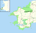
Fichier:Preseli Mountains map.svg
Apparence

Taille de cet aperçu PNG pour ce fichier SVG : 656 × 600 pixels. Autres résolutions : 263 × 240 pixels | 525 × 480 pixels | 840 × 768 pixels | 1 120 × 1 024 pixels | 2 241 × 2 048 pixels | 1 385 × 1 266 pixels.
Fichier d’origine (Fichier SVG, nominalement de 1 385 × 1 266 pixels, taille : 1,27 Mio)
Historique du fichier
Cliquer sur une date et heure pour voir le fichier tel qu'il était à ce moment-là.
| Date et heure | Vignette | Dimensions | Utilisateur | Commentaire | |
|---|---|---|---|---|---|
| actuel | 11 août 2019 à 23:23 |  | 1 385 × 1 266 (1,27 Mio) | RaviC | {{Information |Description=Map of the Preseli Hills in the Pembrokeshire Coast National Park, UK with the following information shown: *National Park boundary *Administrative borders *Coastline, lakes and rivers *Roads and railways *Urban areas Equirectangular map projection on WGS 84 datum, with N/S stretched 160% Geographic limits: *West: 5.60W *East: 4.55W *North: 52.15N *South: 51.55N |Source= Office of National Statistics [h... |
Utilisation du fichier
La page suivante utilise ce fichier :
Usage global du fichier
Les autres wikis suivants utilisent ce fichier :
- Utilisation sur de.wikipedia.org
- Utilisation sur en.wikipedia.org
