
Fichier:Inner german border herrnburg.jpg
Taille de cet aperçu : 800 × 379 pixels. Autres résolutions : 320 × 151 pixels | 640 × 303 pixels | 1 456 × 689 pixels.
Fichier d’origine (1 456 × 689 pixels, taille du fichier : 474 Kio, type MIME : image/jpeg)
| Ce fichier et sa description proviennent de Wikimedia Commons. | Accéder au fichier sur Commons |
Description
| Description |
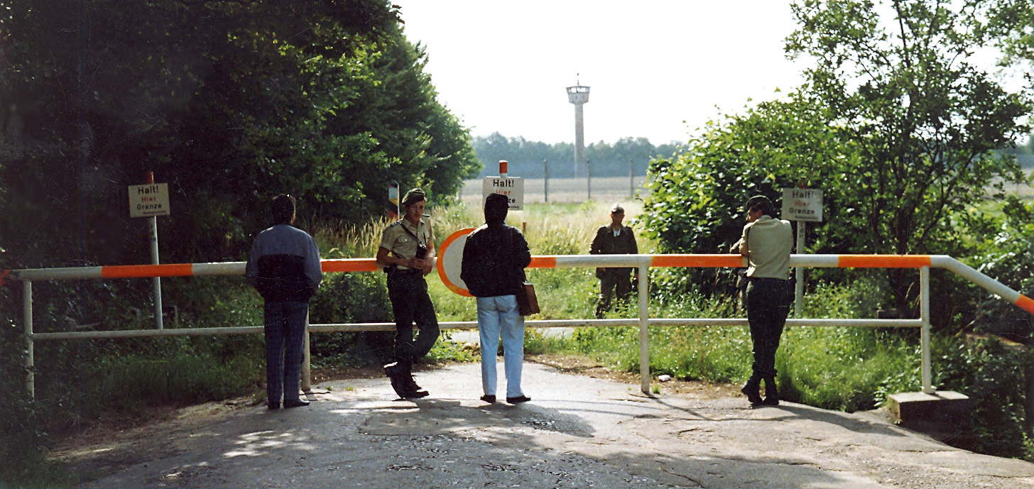
English: (Original description by author) Lübeck remained part of Schleswig-Holstein after the war and was situated directly at the inner German border during the division of Germany into two rival states during the Cold War period. South of the city the border followed the path of the river Wakenitz that separated both countries by less than 10 m in many parts. The northernmost border crossing was in Lübeck's district of Schlutup. My historical picture here shows the former border between Lübeck and "German Democratic Republic" with the little village Herrnburg in Mecklenburg. Behind the border barrier we can see an East German border-soldier of the "National Peoples' Army", and behind him one of the several watch towers to guard the border against those attempting to escape. On this side of the border are two officers of the West German Frontier Police (Bundesgrenzschutz), today called Federal Police (Bundespolizei). |
| Date | |
| Source | https://www.flickr.com/photos/libaer2002/3382170909/ |
| Auteur | Anonyme |
| Autorisation (Réutilisation de ce fichier) |
|
Conditions d’utilisation
Ce fichier est disponible selon les termes de la licence Creative Commons Attribution – Partage dans les Mêmes Conditions 2.0 Générique
- Vous êtes libre :
- de partager – de copier, distribuer et transmettre cette œuvre
- d’adapter – de modifier cette œuvre
- Sous les conditions suivantes :
- paternité – Vous devez donner les informations appropriées concernant l'auteur, fournir un lien vers la licence et indiquer si des modifications ont été faites. Vous pouvez faire cela par tout moyen raisonnable, mais en aucune façon suggérant que l’auteur vous soutient ou approuve l’utilisation que vous en faites.
- partage à l’identique – Si vous modifiez, transformez ou vous basez sur cet élément, vous devez distribuer votre contribution sous une license identique ou compatible à celle de l’original.
| Cette image, qui provient de Flickr, a été vérifiée le 24 octobre 2009 par l'administrateur ou l'utilisateur de confiance (trusted user) PeterSymonds, qui a confirmé qu'à cette date, elle était publiée sur Flickr sous cette licence. |
Historique du fichier
Cliquer sur une date et heure pour voir le fichier tel qu'il était à ce moment-là.
| Date et heure | Vignette | Dimensions | Utilisateur | Commentaire | |
|---|---|---|---|---|---|
| actuel | 24 octobre 2009 à 17:45 | | 1 456 × 689 (474 Kio) | ChrisO | {{Information |Description={{en|1=(Original description by author) Lübeck remained part of Schleswig-Holstein after the war and was situated directly at the inner German border during the division of Germany into two rival states in the Cold War period. |
Utilisation du fichier
La page suivante utilise ce fichier :
Usage global du fichier
Les autres wikis suivants utilisent ce fichier :
- Utilisation sur ar.wikipedia.org
- Utilisation sur ceb.wikipedia.org
- Utilisation sur ce.wikipedia.org
- Utilisation sur de.wikipedia.org
- Utilisation sur en.wikipedia.org
- Utilisation sur es.wikipedia.org
- Utilisation sur eu.wikipedia.org
- Utilisation sur fr.wikipedia.org
- Utilisation sur hu.wikipedia.org
- Utilisation sur it.wikipedia.org
- Utilisation sur ka.wikipedia.org
- Utilisation sur ku.wikipedia.org
- Utilisation sur nl.wikipedia.org
- Utilisation sur pl.wikipedia.org
- Utilisation sur pms.wikipedia.org
- Utilisation sur pt.wikipedia.org
- Utilisation sur ro.wikipedia.org
- Utilisation sur ru.wikipedia.org
- Utilisation sur sr.wikipedia.org
- Utilisation sur tt.wikipedia.org
- Utilisation sur uk.wikipedia.org
- Utilisation sur uz.wikipedia.org
- Utilisation sur vi.wikipedia.org
- Utilisation sur www.wikidata.org
- Utilisation sur zh.wikipedia.org