
Fichier:French Southern and Antarctic Lands-CIA WFB Map.png
Pas de plus haute résolution disponible.
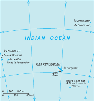
French_Southern_and_Antarctic_Lands-CIA_WFB_Map.png (328 × 352 pixels, taille du fichier : 7 Kio, type MIME : image/png)
| Ce fichier et sa description proviennent de Wikimedia Commons. | Accéder au fichier sur Commons |
Cette image est dans le domaine public parce que son contenu provient du World Factbook, édité par la Central Intelligence Agency des États-Unis d’Amérique.
|
 |
Historique du fichier
Cliquer sur une date et heure pour voir le fichier tel qu'il était à ce moment-là.
| Date et heure | Vignette | Dimensions | Utilisateur | Commentaire | |
|---|---|---|---|---|---|
| actuel | 21 janvier 2006 à 10:30 | | 328 × 352 (7 Kio) | Hoshie | Updated map of the French Southern and Antarctic Lands from CIA Factbook, 10 Jan 06 rev. |
| 27 mars 2005 à 09:13 |  | 330 × 355 (3 Kio) | Wolfman~commonswiki | {{CIA-map}} |
Utilisation du fichier
La page suivante utilise ce fichier :
Usage global du fichier
Les autres wikis suivants utilisent ce fichier :
- Utilisation sur en.wikisource.org
- Utilisation sur fr.wikipedia.org
- Utilisation sur hu.wikipedia.org